Featured Publications
2025
 |
June 2025 Coverage-Limiting Factors Affecting the Monitoring of Urban Emissions With the Orbiting Carbon Observatory Missions DOI: 10.1029/2024AV001630 Project(s): Chatterjee (CMS 2023) |
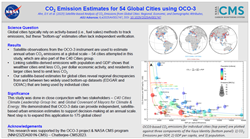 |
June 2025 Satellite‐based analysisof CO2 emissions from global cities: Regional, economic, and demographic attributes. DOI: 10.1029/2025AV001747 Project(s): Chatterjee (CMS 2023) |
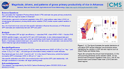 |
May 2025 Magnitude, drivers, and patterns of gross primary productivity of rice in Arkansas using a calibrated vegetation photosynthesis model DOI: 10.1016/j.agrformet.2025.110583 Project(s): Runkle (CMS 2020) |
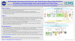 |
April 2025 The North American Greenhouse Gas Budget: Emissions, Removals, and Integration for CO2, CH4, and N2O (2010-2019): Results From the Second REgional Carbon Cycle Assessment and Processes Study (RECCAP2) DOI: 10.1029/2024GB008310 Project(s): Chatterjee (CMS 2018); Poulter (CMS 2020); Hayes (CMS 2023) |
 |
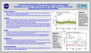
March 2025 Global Carbon Budget 2024 DOI: 10.5194/essd-17-965-2025 Project(s): Hurtt (CMS 2020) |
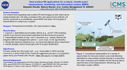 |
February 2025 Near-surface remote sensing applications for a robust, climate-smart measurement, monitoring, and information system (MMIS) DOI: 10.1080/17583004.2025.2465361 Project(s): Runkle (CMS 2020); Barnes (CMS 2022) |
 |
February 2025 Spatial resolution for forest carbon maps DOI: 10.1126/science.adt6811 Project(s): Duncanson (CMS 2022); Hurtt (CMS 2023) |
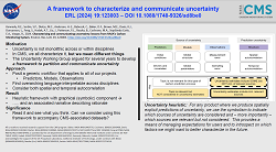 |
February 2025 Characterizing and communicating uncertainty: lessons from NASA's Carbon Monitoring System DOI: 10.1088/1748-9326/ad8be0 Project(s): Baker (CMS 2014); Kennedy (CMS 2015); Dietze (CMS 2016); Hudak (CMS 2018); Lin (CMS 2018); Cochrane (CMS 2018); Dietze (CMS 2020); Kennedy (CMS 2020); Feng (CMS 2020); Davis (CMS 2020); Hudak (CMS 2022); Liu (CMS 2023) |
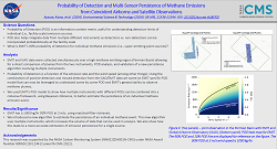 |
January 2025 Probability of Detection and Multi-Sensor Persistence of Methane Emissions from Coincident Airborne and Satellite Observations DOI: 10.1021/acs.est.4c06702 Project(s): Cusworth (CMS 2022) |
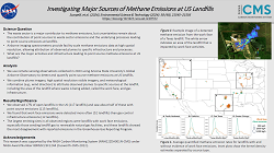 |
January 2025 Investigating Major Sources of Methane Emissions at US Landfills DOI: 10.1021/acs.est.4c07572 Project(s): Cusworth (CMS 2022) |
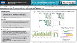 |
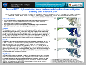
January 2025 Beyond MRV: Combining remote sensing and ecosystem modeling for geospatial monitoring and attribution of forest carbon fluxes over Maryland, USA DOI: 10.1088/1748-9326/ad9035 Project(s): Hurtt (CMS 2020) |
2024
 |
October 2024 Intergovernmental Panel on Climate Change (IPCC) Tier 1 forest biomass estimates from Earth Observation DOI: 10.1038/s41597-024-03930-9 Project(s): Duncanson (CMS 2022) |
 |
July 2024 Evaluation of Vertical Patterns in Chlorophyll-A Derived From a Data Assimilating Model of Satellite-Based Ocean Color DOI: 10.1029/2023EA003378 Project(s): Arteaga (CMS 2022) |
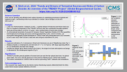 |
June 2024 Trends and Drivers of Regional Scale Terrestrial Sources and Sinks of Carbon Dioxide: An overview of the TRENDY Project. DOI: 10.1029/2024GB008102 Project(s): Hurtt (CMS 2020) |
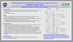 |
June 2024 Modeling exports of dissolved organic carbon from landscapes: a review of challenges and opportunities DOI: 10.1088/1748-9326/ad3cf8 Project(s): Hayes (CMS 2020); Hayes (CMS 2023) |
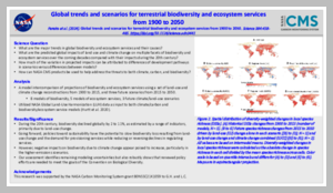 |
April 2024 Global trends and scenarios for terrestrial biodiversity and ecosystem services from 1900 to 2050 DOI: 10.1126/science.adn3441 Project(s): Hurtt (CMS 2020) |
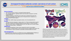 |
March 2024 Revealing the hidden carbon in forested wetland soils DOI: 10.1038/s41467-024-44888-x Project(s): Moskal (CMS 2022) |
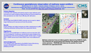 |
March 2024 Geostationary satellite observations of extreme and transient methane emissions from oil and gas infrastructure DOI: 10.1073/pnas.2310797120 Project(s): Jacob (CMS 2020) |
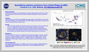 |
March 2024 Quantifying methane emissions from United States landfills DOI: 10.1126/science.adi7735 Project(s): Duren (CMS 2018); Cusworth (CMS 2022) |
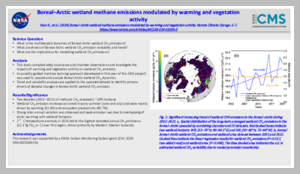 |
February 2024 Boreal-Arctic wetland methane emissions modulated by warming and vegetation activity DOI: 10.1038/s41558-024-01933-3 Project(s): Zhu (CMS 2020) |
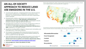 |
February 2024 Harnessing the Land Sector to Achieve U.S. Climate Goals: An all-of-society approach to meeting our climate goals and bolstering the carbon sink by 2035. Project(s): Hurtt (CMS 2020) |
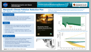 |
February 2024 "Potential Pathways for Growing the Forest Carbon Sink." In Maryland's Climate Pollution Reduction Plan. Appendix Forestry and Land Use Sector Modeling. Project(s): Hurtt (CMS 2020) |
 |
January 2024 High-Fidelity Deep Approximation of Ecosystem Simulation over Long-Term at Large Scale DOI: 10.1145/3589132.3625577 Project(s): Hurtt (CMS 2020) |
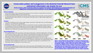 |
January 2024 Conservation policies and management in the Ukrainian Emerald Network have maintained reforestation rate despite the war DOI: 10.1038/s43247-023-01099-4 Project(s): Hurtt (CMS 2020) |
 |
January 2024 Global Carbon Budget 2023 DOI: 10.5194/essd-15-5301-2023 Project(s): Hurtt (CMS 2020); Liu (CMS 2023) |
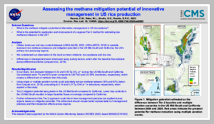 |
January 2024 Assessing the methane mitigation potential of innovative management in US rice production DOI: 10.1088/1748-9326/ad0925 Project(s): Runkle (CMS 2020) |
2023
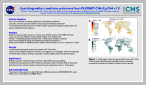 |
October 2023 Upscaling Wetland Methane Emissions From the FLUXNET-CH4 Eddy Covariance Network (UpCH4 v1.0): Model Development, Network Assessment, and Budget Comparison DOI: 10.1029/2023AV000956 Project(s): Zhu (CMS 2020) |
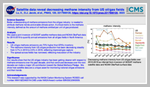 |
July 2023 Observation-derived 2010-2019 trends in methane emissions and intensities from US oil and gas fields tied to activity metrics DOI: 10.1073/pnas.2217900120 Project(s): Jacob (CMS 2020) |
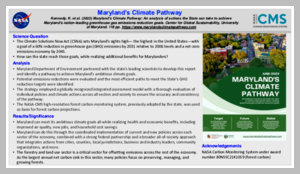 |
July 2023 (2023) Maryland’s Climate Pathway: An analysis of actions the State can take to achieve Maryland’s nation-leading greenhouse gas emissions reduction goals. Project(s): Hurtt (CMS 2020) |
 |
June 2023 An approach to estimating forest biomass while quantifying estimate uncertainty and correcting bias in machine learning maps DOI: 10.1016/j.rse.2023.113678 Project(s): Hudak (CMS 2018) |
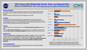 |
June 2023 Assessment of the NASA carbon monitoring system wet carbon stakeholder community: data needs, gaps, and opportunities DOI: 10.1088/1748-9326/ace208 Project(s): Poulter (CMS 2018); Mitchell (CMS 2018); Poulter (CMS 2020) |
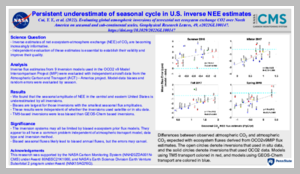 |
April 2023 Evaluating Global Atmospheric Inversions of Terrestrial Net Ecosystem Exchange CO 2 Over North America on Seasonal and Sub-Continental Scales DOI: 10.1029/2022GL100147 Project(s): Davis (CMS 2020) |
 |
April 2023 Changing cropland in changing climates: quantifying two decades of global cropland changes DOI: 10.1088/1748-9326/acca97 Project(s): Hurtt (CMS 2020) |
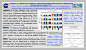 |
March 2023 Comparison of Model-Assisted Endogenous Poststratification Methods for Estimation of Above-Ground Biomass Change in Oregon, USA DOI: 10.3390/rs14236024 Project(s): Hudak (CMS 2018) |
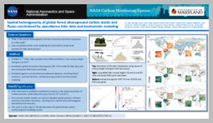 |
March 2023 Spatial heterogeneity of global forest aboveground carbon stocks and fluxes constrained by spaceborne lidar data and mechanistic modeling DOI: 10.1111/gcb.16682 Project(s): Hurtt (CMS 2020) |
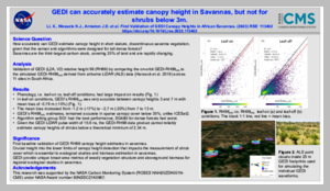 |
March 2023 First validation of GEDI canopy heights in African savannas DOI: 10.1016/j.rse.2022.113402 Project(s): Armston (CMS 2020) |
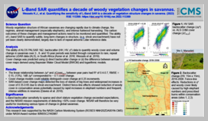 |
March 2023 Quantifying the sensitivity of L-Band SAR to a decade of vegetation structure changes in savannas DOI: 10.1016/j.rse.2022.113369 Project(s): Armston (CMS 2020) |
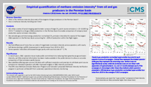 |
February 2023 Empirical quantification of methane emission intensity from oil and gas producers in the Permian basin DOI: 10.1088/1748-9326/acb27e Project(s): Duren (CMS 2018) |
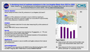 |
February 2023 A declining trend of methane emissions in the Los Angeles Basin from 2015 to 2020 DOI: 10.1088/1748-9326/acb6a9 Project(s): Duren (CMS 2018) |
 |
January 2023 Impact of radiation variations on temporal upscaling of instantaneous Solar-Induced Chlorophyll Fluorescence DOI: 10.1016/j.agrformet.2022.109197 Project(s): Lin (CMS 2018) |
2022
 |
August 2022 Carbon monitoring and above ground biomass trends: Anchor forest opportunities for tribal, private and federal relationships DOI: 10.1016/j.tfp.2022.100302 Project(s): Hudak (CMS 2018) |
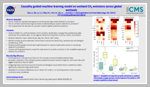 |
August 2022 Causality guided machine learning model on wetland CH4 emissions across global wetlands DOI: 10.1016/j.agrformet.2022.109115 Project(s): Zhu (CMS 2020) |
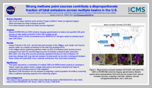 |
August 2022 Strong methane point sources contribute a disproportionate fraction of total emissions across multiple basins in the United States DOI: 10.1073/pnas.2202338119 Project(s): Duren (CMS 2015); Duren (CMS 2018) |
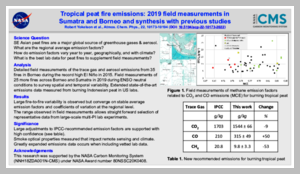 |
August 2022 Tropical peat fire emissions: 2019 field measurements in Sumatra and Borneo and synthesis with previous studies DOI: 10.5194/acp-22-10173-2022 Project(s): Cochrane (CMS 2013); Cochrane (CMS 2015); Cochrane (CMS 2018) |
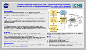 |
July 2022 Scientist-stakeholder relationships drive carbon data product transfer effectiveness within NASA program DOI: 10.1088/1748-9326/ac87bf Project(s): Poulter (CMS 2018); Hurtt (CMS 2020) |
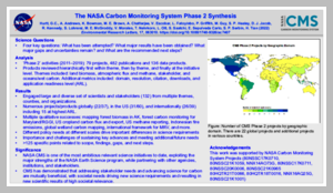 |
June 2022 The NASA Carbon Monitoring System Phase 2 synthesis: scope, findings, gaps and recommended next steps DOI: 10.1088/1748-9326/ac7407 Project(s): Lohrenz (CMS 2014); Kennedy (CMS 2015); Dietze (CMS 2016); Hurtt (CMS 2016); Healey (CMS 2016); Chatterjee (CMS 2018); Dietze (CMS 2020); Kennedy (CMS 2020); Hurtt (CMS 2020) |
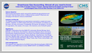 |
June 2022 Balancing Greenhouse Gas Budgets: Accounting for Natural and Anthropogenic Flows of CO2 and Other Trace Gases. Project(s): ; Poulter (CMS 2018) |
 |
June 2022 A Field Study of Tropical Peat Fire Behaviour and Associated Carbon Emissions DOI: 10.3390/fire5030062 Project(s): Cochrane (CMS 2013); Cochrane (CMS 2015); Cochrane (CMS 2018) |
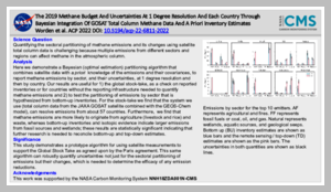 |
June 2022 The 2019 methane budget and uncertainties at 1deg resolution and each country through Bayesian integration Of GOSAT total column methane data and a priori inventory estimates DOI: 10.5194/acp-22-6811-2022 Project(s): Worden (CMS 2018) |
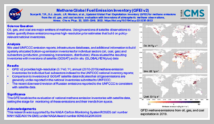 |
April 2022 Updated Global Fuel Exploitation Inventory (GFEI) for methane emissions from the oil, gas, and coal sectors: evaluation with inversions of atmospheric methane observations DOI: 10.5194/acp-22-3235-2022 Project(s): Jacob (CMS 2020) |
 |
April 2022 A novel model-data fusion approach to terrestrial carbon cycle reanalysis across the contiguous U.S using SIPNET and PEcAn state data assimilation system v. 1.7.2 DOI: 10.5194/gmd-2021-236 Project(s): Dietze (CMS 2016) |
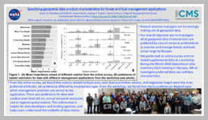 |
March 2022 Specifying geospatial data product characteristics for forest and fuel management applications DOI: 10.1088/1748-9326/ac5ee0 Project(s): Hudak (CMS 2018) |
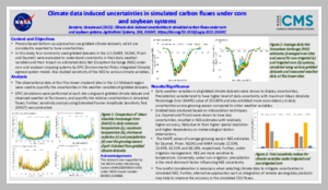 |
March 2022 Climate data induced uncertainties in simulated carbon fluxes under corn and soybean systems DOI: 10.1016/j.agsy.2021.103341 Project(s): Bandaru (CMS 2020) |
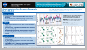 |
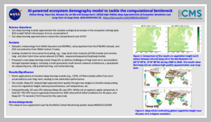
February 2022 Global Evaluation of the Ecosystem Demography Model (ED v3.0) DOI: 10.5194/gmd-2021-292 Project(s): Hurtt (CMS 2016); Chatterjee (CMS 2018); Hurtt (CMS 2020) |
2021
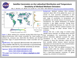 |
October 2021 Satellite Constraints on the Latitudinal Distribution and Temperature Sensitivity of Wetland Methane Emissions DOI: 10.1029/2021AV000408 Project(s): Jacob (CMS 2014); Worden (CMS 2018) |
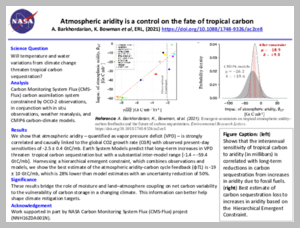 |
October 2021 Emergent constraints on tropical atmospheric aridity--carbon feedbacks and the future of carbon sequestration DOI: 10.1088/1748-9326/ac2ce8 Project(s): Bowman (CMS 2016) |
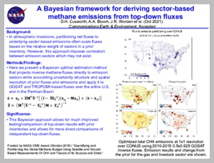 |
October 2021 A Bayesian framework for deriving sector-based methane emissions from top-down fluxes DOI: 10.1038/s43247-021-00312-6 Project(s): Worden (CMS 2018) |
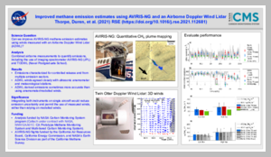 |
September 2021 Improved methane emission estimates using AVIRIS-NG and an Airborne Doppler Wind Lidar DOI: 10.1016/j.rse.2021.112681 Project(s): Duren (CMS 2015); Duren (CMS 2018) |
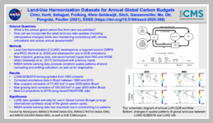 |
August 2021 Land-Use Harmonization Datasets for Annual Global Carbon Budgets DOI: 10.5194/essd-2020-388 Project(s): Hurtt (CMS 2016); Hurtt (CMS 2020) |
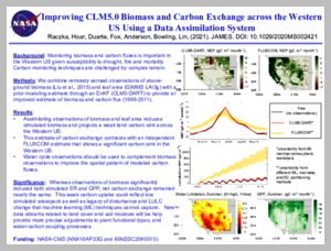 |
July 2021 Improving CLM5.0 Biomass and Carbon Exchange Across the Western United States Using a Data Assimilation System DOI: 10.1029/2020MS002421 Project(s): Lin (CMS 2015); Lin (CMS 2018) |
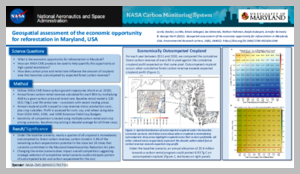 |
July 2021 Geospatial assessment of the economic opportunity for reforestation in Maryland, USA DOI: 10.1088/1748-9326/ac109a Project(s): Hurtt (CMS 2014); Hurtt (CMS 2016); Hurtt (CMS 2020) |
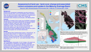 |
June 2021 Spatiotemporal assessment of land use/land cover change and associated carbon emissions and uptake in the Mekong River Basin DOI: 10.1016/j.rse.2021.112336 Project(s): Olofsson (CMS 2015) |
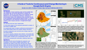 |
June 2021 A Suite of Tools for Continuous Land Change Monitoring in Google Earth Engine DOI: 10.3389/fclim.2020.576740 Project(s): Olofsson (CMS 2015) |
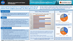 |
May 2021 Context and future directions for integrating forest carbon into sub-national climate mitigation planning in the RGGI region of the U.S. DOI: 10.1088/1748-9326/abe6c2 Project(s): Hurtt (CMS 2016); Hurtt (CMS 2020) |
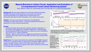 |
May 2021 Beyond biomass to carbon fluxes: application and evaluation of a comprehensive forest carbon monitoring system DOI: 10.1088/1748-9326/abf06d Project(s): Williams (CMS 2014); Kennedy (CMS 2015) |
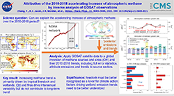 |
May 2021 Attribution of the accelerating increase in atmospheric methane during 2010-2018 by inverse analysis of GOSAT observations DOI: 10.5194/acp-21-3643-2021 Project(s): Jacob (CMS 2016) |
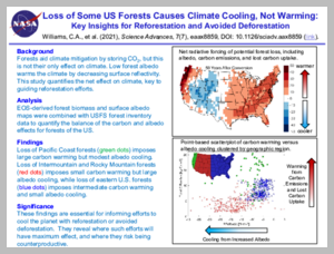 |
April 2021 Climate impacts of U.S. forest loss span net warming to net cooling DOI: 10.1126/sciadv.aax8859 Project(s): Williams (CMS 2014); Kennedy (CMS 2015) |
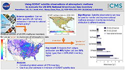 |
April 2021 2010-2015 North American methane emissions, sectoral contributions, and trends: a high-resolution inversion of GOSAT observations of atmospheric methane DOI: 10.5194/acp-21-4339-2021 Project(s): Jacob (CMS 2016); Worden (CMS 2018) |
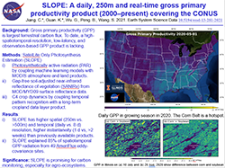 |
April 2021 A daily, 250 m and real-time gross primary productivity product (2000-present) covering the contiguous United States DOI: 10.5194/essd-13-281-2021 Project(s): Guan (CMS 2016) |
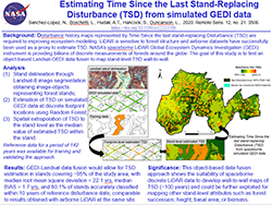 |
April 2021 Estimating Time Since the Last Stand-Replacing Disturbance (TSD) from Spaceborne Simulated GEDI Data: A Feasibility Study DOI: 10.3390/rs12213506 Project(s): Hudak (CMS 2018); Worden (CMS 2018) |
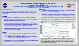 |
February 2021 Carbon Fixation Trends in Eleven of the World's Largest Lakes: 2003-2018 DOI: 10.3390/w12123500 Project(s): Sayers (CMS 2016) |
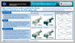 |
February 2021 High-resolution forest carbon modelling for climate mitigation planning over the RGGI region, USA DOI: 10.1088/1748-9326/abe4f4 Project(s): Hurtt (CMS 2016); Hurtt (CMS 2020) |
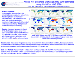 |
February 2021 Carbon Monitoring System Flux Net Biosphere Exchange 2020 (CMS-Flux NBE 2020) DOI: 10.5194/essd-13-299-2021 Project(s): Bowman (CMS 2016) |
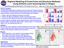 |
February 2021 Regional Modeling of Forest Fuels and Structural Attributes Using Airborne Laser Scanning Data in Oregon DOI: 10.3390/rs13020261 Project(s): Hudak (CMS 2018) |
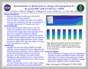 |
January 2021 Harmonization of global land use change and management for the period 850-2100 (LUH2) for CMIP6 DOI: 10.5194/gmd-13-5425-2020 Project(s): Hurtt (CMS 2016) |
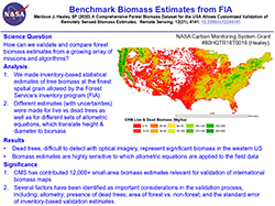 |
January 2021 A Comprehensive Forest Biomass Dataset for the USA Allows Customized Validation of Remotely Sensed Biomass Estimates DOI: 10.3390/rs12244141 Project(s): Healey (CMS 2016) |
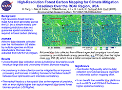 |
January 2021 High-resolution forest carbon mapping for climate mitigation baselines over the RGGI region, USA DOI: 10.1088/1748-9326/abd2ef Project(s): Dubayah (CMS 2011); Hurtt (CMS 2014); Hurtt (CMS 2016); Hurtt (CMS 2020) |
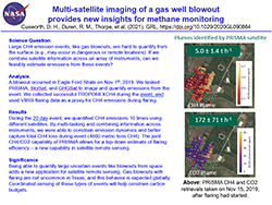 |
January 2021 Multisatellite Imaging of a Gas Well Blowout Enables Quantification of Total Methane Emissions DOI: 10.1029/2020GL090864 Project(s): Duren (CMS 2018) |
2020
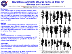 |
October 2020 New 3D measurements of large redwood trees for biomass and structure DOI: 10.1038/s41598-020-73733-6 Project(s): Fatoyinbo (CMS 2015) |
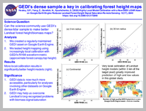 |
September 2020 Highly Local Model Calibration with a New GEDI LiDAR Asset on Google Earth Engine Reduces Landsat Forest Height Signal Saturation DOI: 10.3390/rs12172840 Project(s): Healey (CMS 2016) |
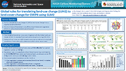 |
August 2020 Global rules for translating land-use change (LUH2) to land-cover change for CMIP6 using GLM2 DOI: 10.5194/gmd-13-3203-2020 Project(s): Hurtt (CMS 2016) |
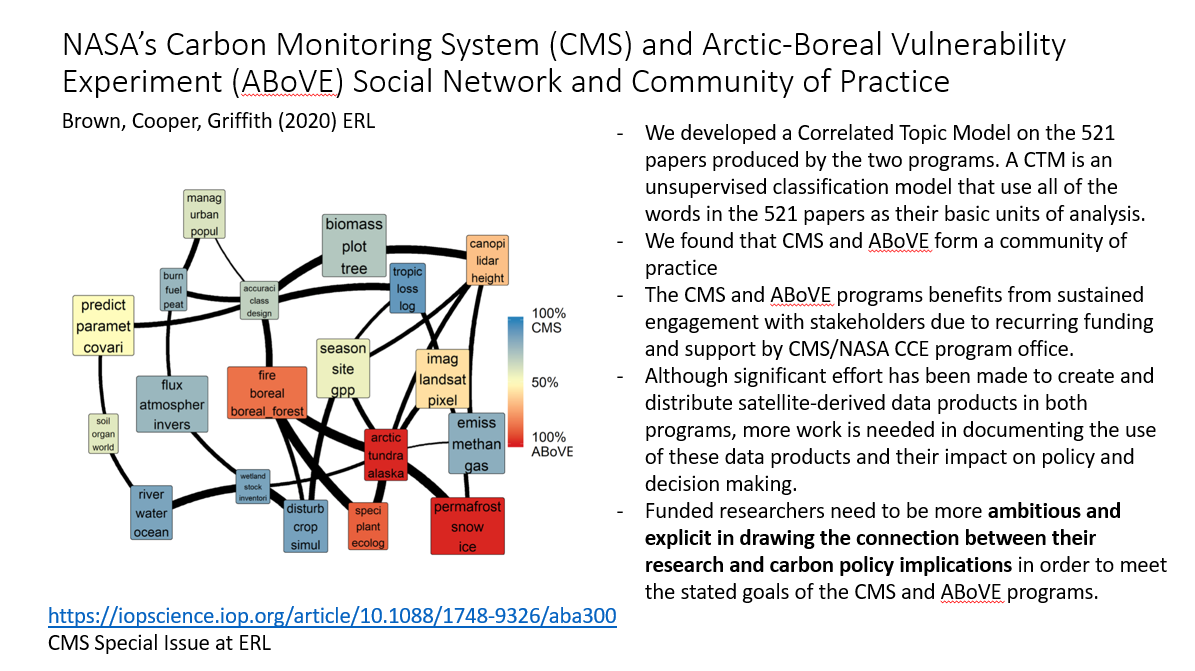 |
July 2020 NASA's carbon monitoring system (CMS) and arctic-boreal vulnerability experiment (ABoVE) social network and community of practice DOI: 10.1088/1748-9326/aba300 Project(s): Escobar (CMS 2015); Poulter (CMS 2018) |
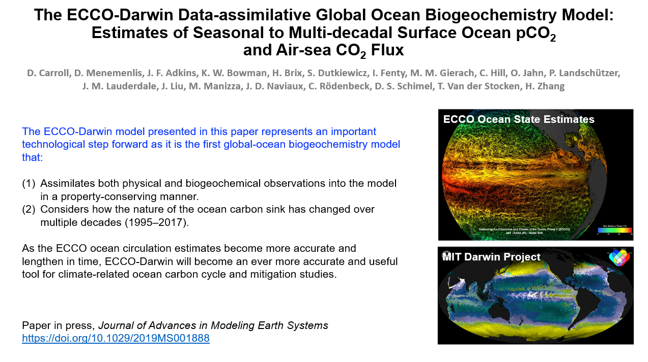 |
July 2020 The ECCO-Darwin Data-Assimilative Global Ocean Biogeochemistry Model: Estimates of Seasonal to Multidecadal Surface Ocean p CO 2 and Air-Sea CO 2 Flux DOI: 10.1029/2019MS001888 Project(s): Bowman (CMS 2016) |
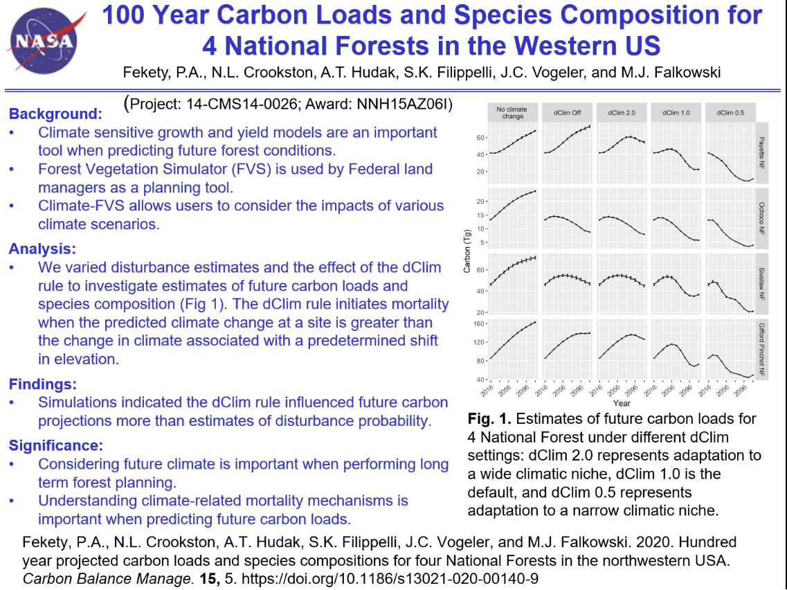 |
June 2020 Hundred year projected carbon loads and species compositions for four National Forests in the northwestern USA DOI: 10.1186/s13021-020-00140-9 Project(s): Hudak (CMS 2014) |
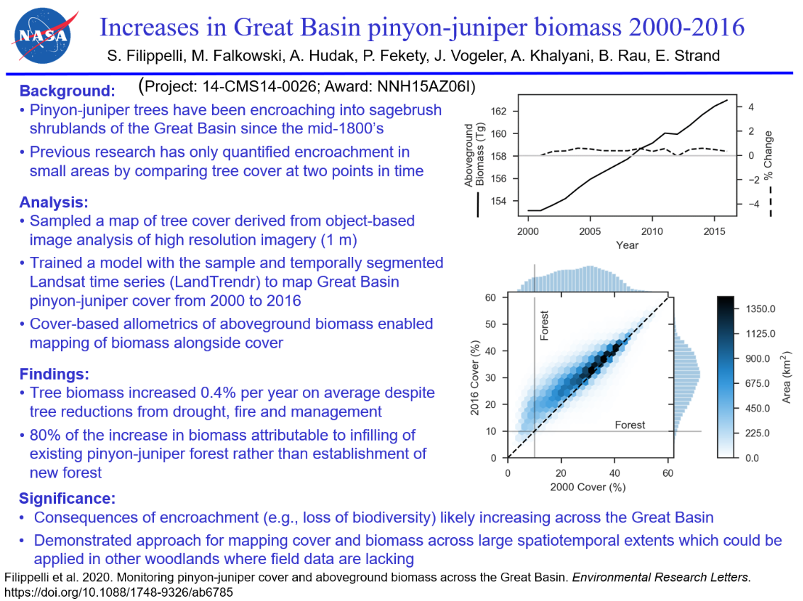 |
June 2020 Monitoring pinyon-juniper cover and aboveground biomass across the Great Basin DOI: 10.1088/1748-9326/ab6785 Project(s): Hudak (CMS 2014) |
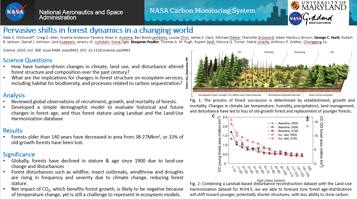 |
May 2020 Pervasive shifts in forest dynamics in a changing world DOI: 10.1126/science.aaz9463 Project(s): Hurtt (CMS 2016); Poulter (CMS 2018) |
 |
April 2020 Biomass estimation from simulated GEDI, ICESat-2 and NISAR across environmental gradients in Sonoma County, California DOI: 10.1016/j.rse.2020.111779 Project(s): Fatoyinbo (CMS 2015) |
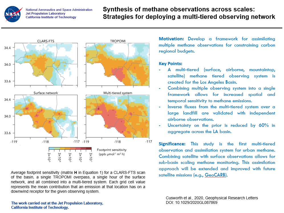 |
April 2020 Synthesis of Methane Observations Across Scales: Strategies for Deploying a Multitiered Observing Network DOI: 10.1029/2020GL087869 Project(s): Duren (CMS 2015) |
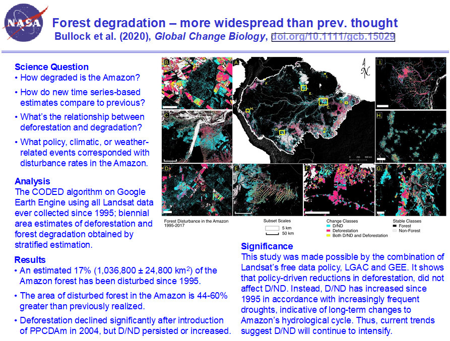 |
March 2020 Satellite-based estimates reveal widespread forest degradation in the Amazon DOI: 10.1111/gcb.15029 Project(s): Olofsson (CMS 2015) |
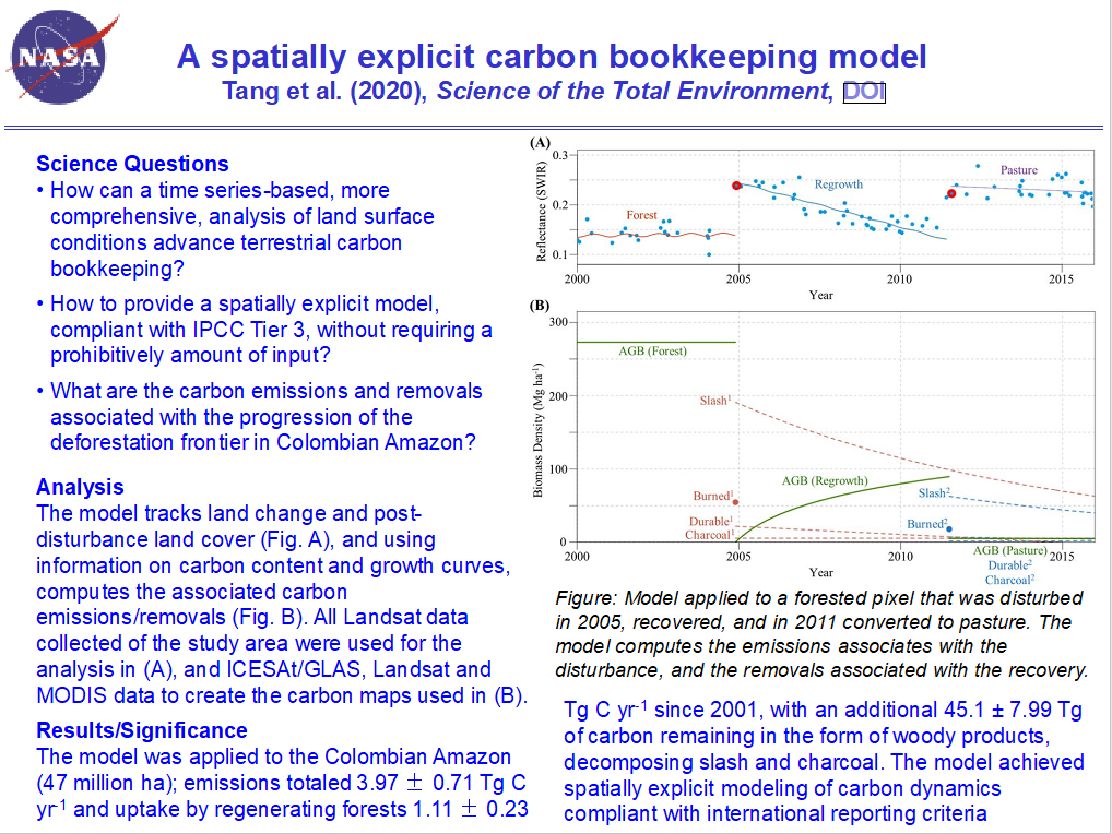 |
March 2020 Spatiotemporal tracking of carbon emissions and uptake using time series analysis of Landsat data: A spatially explicit carbon bookkeeping model DOI: 10.1016/j.scitotenv.2020.137409 Project(s): Olofsson (CMS 2015) |
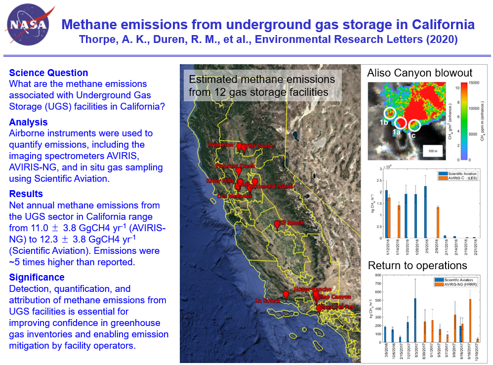 |
March 2020 Methane emissions from underground gas storage in California DOI: 10.1088/1748-9326/ab751d Project(s): Duren (CMS 2015) |
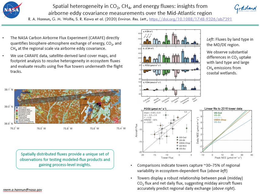 |
February 2020 Spatial heterogeneity in CO2, CH4, and energy fluxes: insights from airborne eddy covariance measurements over the Mid-Atlantic region DOI: 10.1088/1748-9326/ab7391 Project(s): Kawa (CMS 2015) |
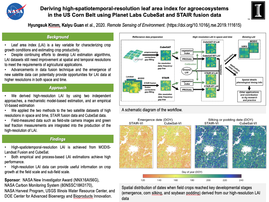 |
January 2020 Deriving high-spatiotemporal-resolution leaf area index for agroecosystems in the U.S. Corn Belt using Planet Labs CubeSat and STAIR fusion data DOI: 10.1016/j.rse.2019.111615 Project(s): Guan (CMS 2016) |
2019
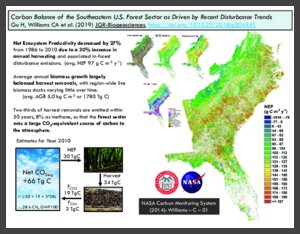 |
September 2019 The Carbon Balance of the Southeastern U.S. Forest Sector as Driven by Recent Disturbance Trends DOI: 10.1029/2018JG004841 Project(s): Williams (CMS 2014) |
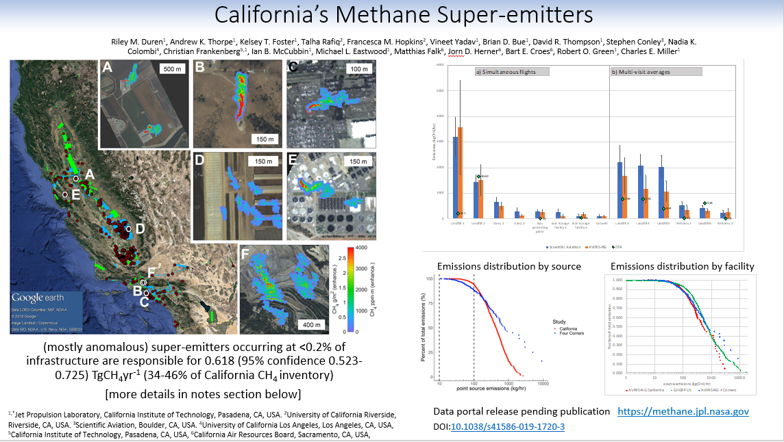 |
August 2019 California's methane super-emitters DOI: 10.1038/s41586-019-1720-3 Project(s): Duren (CMS 2015) |
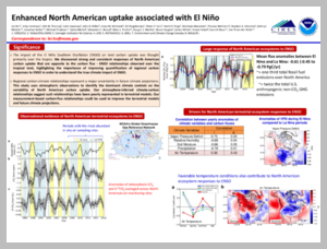 |
July 2019 Enhanced North American carbon uptake associated with El Nino DOI: 10.1126/sciadv.aaw0076 Project(s): Andrews (CMS 2011); Andrews (CMS 2014); Andrews (CMS 2016) |
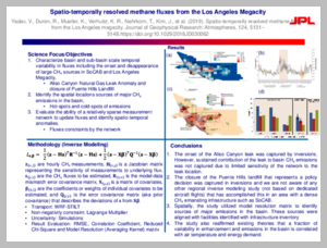 |
May 2019 Spatio-temporally Resolved Methane Fluxes From the Los Angeles Megacity DOI: 10.1029/2018JD030062 Project(s): Duren (CMS 2015) |
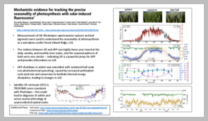 |
May 2019 Mechanistic evidence for tracking the seasonality of photosynthesis with solar-induced fluorescence DOI: 10.1073/pnas.1900278116 Project(s): Lin (CMS 2015) |
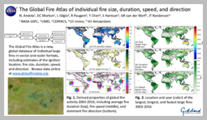 |
March 2019 The Global Fire Atlas of individual fire size, duration, speed and direction DOI: 10.5194/essd-11-529-2019 Project(s): Randerson (CMS 2016) |
 |
March 2019 Beyond MRV: high-resolution forest carbon modeling for climate mitigation planning over Maryland, USA DOI: 10.1088/1748-9326/ab0bbe Project(s): Hurtt (CMS 2014); Hurtt (CMS 2016) |
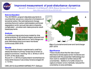 |
February 2019 Continuous monitoring of land change activities and post-disturbance dynamics from Landsat time series: A test methodology for REDD+ reporting DOI: 10.1016/j.rse.2019.01.013 Project(s): Olofsson (CMS 2015) |
+ View Older Archive
- NASA Official: Jon Ranson
- Curator: Leanne Kendig